Maps, Maaaaaaps 🎶
plus, robot hiking pants, a Death Valley scorcher, Rim of the Valley Trail, an event at the Autry, and more
Hiking with Hand-Drawn Maps

Confession here: I can be pretty absent-minded. I will forget how long it takes me to get ready. I will forget something very important you told me last week. I will forget people’s names (never the names of their dogs though). But one area where my memory has always been sharp is with a sense of direction.
Sure, I’m decent at driving directions—and at giving driving directions, too—but for some reason my brain really locks in on hiking directions. If I look at a picture from a trail that I took, I can still remember exactly where that spot is, and what junctions I took to get there. I am still fairly confident that if you dropped me off somewhere in the San Gabriel or Santa Monica Mountains, I could figure out generally where I was and how to get out of there at a decent pace (this does not apply to the Pacific Northwest, where I am still learning plants and trying in vain to remember a landscape when it’s covered by trees).
I think this partially comes from being fascinated by maps. Even as a kid,
I would pore over maps and atlases, studying coastlines, mountain ranges, and how the different geographies seemed to affect each other. I know not everyone likes doing this, but at the very least it seems folks who like the outdoors can still spend a very happy afternoon just staring at a map of some imagined trip.
In the age of the smartphone and turn-by-turn GPS directions, this is becoming much less prevalent … even on the trail. And look, they’re really convenient, and I’m not gonna tell you I don’t use them because I absolutely do—but I do think people have forgotten how to make mental maps of their own.
That’s why this travel story from the New York Times (unlocked!) is so fun—it follows a journalist who attempts to walk across Switzerland without a phone or a pre-planned route, relying only on the hand-drawn maps and directions of strangers he met along the way.
Of course there are tons of beautiful photos, as well as many of the scanned hand-drawn maps. As a map nerd, I find the wide range of visual styles to be totally fascinating. You can tell a lot about a person, their culture, and even the moment in history by what’s important enough to be depicted on a map—and this style of traveling honestly sounds super enticing.
That said, always carry an actual map with you. Safety first, you know!
Oh yeah, here’s the song:
Modern Hiking
Good stuff from the Modern Hiker site
Check out the Rim of the Valley
This week, we’ve added the Rim of the Valley Trail in the foothills of the San Gabriel Mountains. Astute readers may note that this trail shares the same name as the planned (and very studied) proposed expansion of the Santa Monica Mountains National Recreation Area, but this short route is simply the section of trail that gave that expansion plan its name (and hopefully, the trailhead to a much longer hiking adventure someday). The Rim of the Valley Trail is a low-effort, high-reward hike for views and solitude, and you can check out the brand new trail guide for it right here.
I’ll Be at the Autry in October
A heads-up! I’ll be selling and signing books at the Autry Museum in Griffith Park on Sunday, October 6th as part of their annual block party.
Keep an eye on this newsletter for more information as I get it — maybe I’ll do a quick group hike in the park before the block party kicks off for you early-risers? I know I’m missing my Trails Cafe pastries …
Your Parks
Your Places
“I Went to Death Valley to Experience 129 Degrees”

The hottest temperature I have ever experienced was in Portland, Oregon during the 2021 heat dome. The official temperature on June 28th was 114 degrees, and I sat on a shaded porch with my husband and sister drinking mezcal cocktails. I think we made it maybe 15 minutes before we had to hide inside with our air conditioner.
The Atlantic sent writer Ross Andersen to experience 129-degree weather in Death Valley National Park. The writing is terrific, evocative of the heat’s effects on tourists but also touching on the terrain and the Timbisha Shoshone, who still live inside the national park’s boundaries:
I was no stranger to the scorching feel of a desert in high summer. My dad lived amid the red rock of Southern Utah for more than a decade, and I visited him in all seasons. I was just there a few weeks ago when temperatures reached 113. But 129 hits different. When you emerge into that kind of heat from an air-conditioned space, you feel its intensity before the door even closes behind you. It sets upon you from above. It is as though a clingy gargoyle made of flame has landed atop your head and neck. This gargoyle is a creature of pure desire. It wants only one thing, to bring you into thermal equilibrium with the desert. It goes for your soft spots first, reaching into the corners of your eyes, singeing your nostrils. After a few minutes pass, it tries to pull moisture straight through your skin. You feel its pinches and prickles on your forearms and calves. The breeze only makes things worse, by blasting apart the thin and fragile atmosphere of cooled air that millions of your pores produce by sweating. Your heart hammers faster and faster. Your cognition starts to blur. Only eight minutes in, I looked down at my phone. It had shut down entirely. I chose to view that as an act of solidarity.
That said, I love visiting Death Valley, but I like to go in the winter and spring like a normal person.
Tech Talk
Gadgets, Technology, and Hype
Are you in the Market for $5000 Hiking Pants?
I know I certainly am not. But hey, maybe you have a huge wad of cash just burning a hole through all your finances, descending on its way to the earth’s molten core (in which case, I do hope you are a paid subscriber…).
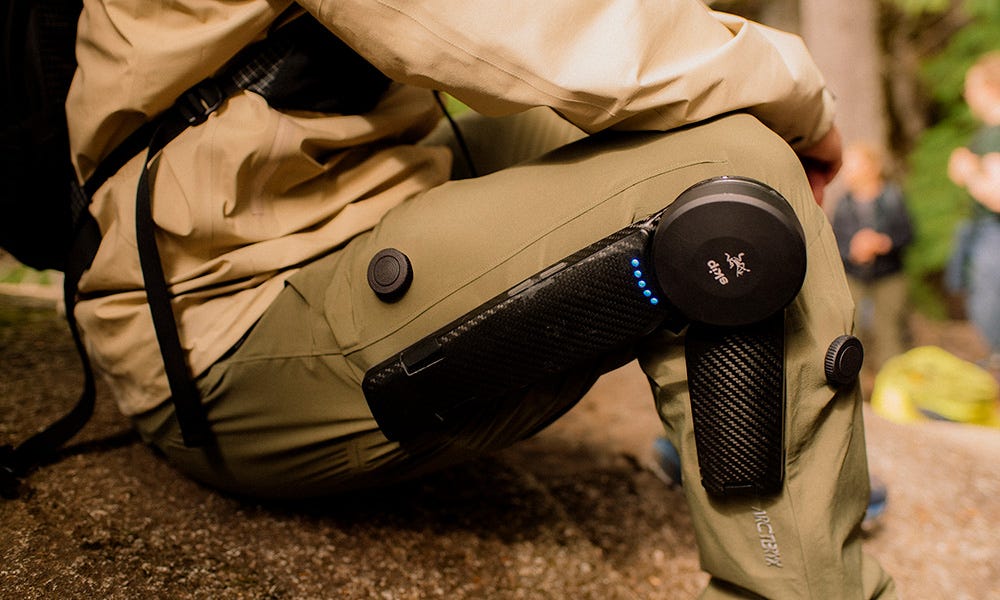
The Manual has a feature on Arc’teryx’s new MO/GO Hiking Pants, which they describe as the company’s “already awesome” Gamma pants with MO/GO wearable robotics added.
MO/GO is short for ‘mountain goat,’ which is pretty cute, even if the price tag is not. The MO/GO system is a chargeable, wearable exoskeleton that claims to boost effective leg strength by 40%, making you feel “up to 30 pounds lighter.” I wrote about this technology earlier this year, and although it’s being marketed toward people who face mobility challenges, you know it’s not long before we start to see this stuff on some sponsored athletes or techbros who want to do the JMT but not without “optimizing the experience” or some nonsense.
Early adopters can reserve their robot legs via the site Skip. And if the price tag is off-putting, the companies are planning on making rental units available in the Western U.S. and Canada.
One More Thing
Oh yeah, before I go …
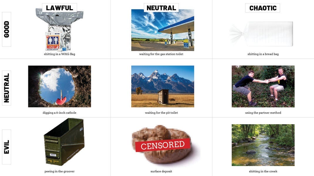
You didn’t know you needed to see this, but Backpacker has produced a Dungeons and Dragons style character alignment chart of outdoor pooping styles. I am a sucker for alignment charts and this one is not only funny, but will help you determine a better way to take care of business the next time you’re on the trail—as well as some ways you absolutely 100% should NEVER take care of said business.
Until next time,
Happy Trails


Wonderful post. We are map simpatico! As a child of 80's and 90's, the road atlas was the only thing that kept me sane on long road trips across America. And the piece in the NYT about hiking in Switzerland was pure magic.